ABOUT THE PLACE
About this place
Robson is a named summit in the southern Ala-Archa mountain area of the Kyrgyz Ala-Too. The nearby Keldy-Choku saddle is a separate geographical feature that helps explain the mountain’s ridge setting. Both lie well beyond the lower park landscape.
The interest is the arrangement of a summit and a connecting saddle above the upper valley. A saddle is a low point on a ridge, while the peak is the higher objective; they should not be treated as interchangeable destinations. Looking back towards the valley and across the enclosing high ground gives this part of Ala-Archa a different character from the wooded park walks near the entrance.
Route grading
Grade not specified
An alpine grade for this exact itinerary is unverified. This does not mean easy or ungraded-pass terrain.
Reaching the same summit does not establish identity with a classified line. No grade is transferred from a different approach.
A grade for this exact ascent line has not been verified. A different route on the same peak may have a different grade.
Grade meanings, skills and equipment ↗
ROUTE OVERVIEW
At a glance
An alternative 20 km ascent from Ala-Archa towards Robson Peak via Keldy-Choku Pass. The descent is not included.
User-supplied reference geometry; not independently field-verified. No alpine grade, access road, season or recommended completion time is established by the file.
Track length: 20.0 km. This distance covers the track shown on the map. Add any approach, return or transfer sections that are outside it.
Is this route for you?
Choose the route after checking the actual start, finish and terrain with a local guide. Mapped geometry alone does not establish technical difficulty. Your group should be comfortable navigating offline and changing plans when conditions deteriorate.
- With children
- Not available
- Dogs
- Check local rules
- Bicycles and pushchairs
- Not available
- Phone coverage
- Do not rely on it
What is nearby?
Chuy Region
Getting there
The first point is the start of the supplied geometry, not a confirmed vehicle-accessible trailhead.
Without a car
Confirm transport to the actual trailhead, not just the nearest town. Agree the return pickup point and a latest contact time before leaving mobile coverage.
By car & parking
Ask locally about road access, entry rules and a permitted place to park. Use the line only for its stated mode of travel and exact scope.
What you will find along the way
An alternative 20 km ascent from Ala-Archa towards Robson Peak via Keldy-Choku Pass. The descent is not included.
- Start 42.5632, 74.4832
A point of the supplied route geometry. It does not by itself confirm a parking area, settlement or safe access. Read the access and route notes before planning your visit.
- End 42.4258, 74.4452
A point of the supplied route geometry. It does not by itself confirm a parking area, settlement or safe access. Read the access and route notes before planning your visit.
Difficult sections & safety
Mountain weather can change quickly. Rain affects traction and river crossings; snow can remain on shaded slopes. Never assume a mapped line confirms a safe crossing or a passable trail. Check recent conditions locally, set a turnaround time and leave your plan with someone who can raise the alarm.
How much time to allow
Historical file time is not a recommended schedule.
When to go
The GPX does not establish a suitable season; assess current conditions for this specific line.
What to bring
- Trail shoes or boots with good grip; layers, sun protection and waterproofs.
- Drinking water, food, a first-aid kit and a headlamp.
- An offline map, downloaded GPX, a charged phone and a power bank.
- An agreed return plan, local contact and a realistic fallback route.
GOOD QUESTIONS
Before you set out
Can I download GPX and KML?
Yes. The downloads above contain this route geometry for an offline navigation app. They do not confirm current conditions.
Has this route been checked recently?
KyrgyzMap has not field-verified this route. The map source and licence are shown below. Look for approved traveller reports and check conditions with local guides.
Can I go with children?
Suitability for children is not confirmed for this exact route. Check terrain, exposure, river crossings and retreat options with a guide before deciding.
How is the elevation profile calculated?
Elevation values come from the source file. Inaccuracies can affect total ascent. Gaps in the track are not joined.
Photo gallery
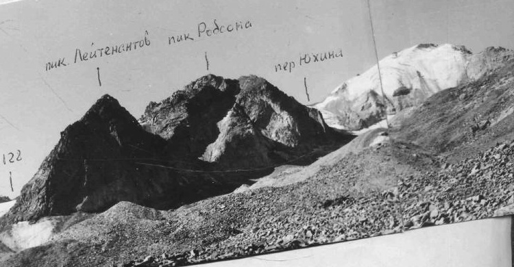
A regional landscape for context; it does not identify every section of the track.
1 photos · select to enlarge
Photographs show named places on this itinerary; they do not document the exact GPX recording.
Photo credits & licences
Photo: MSU Tourist Club expedition led by Vladimir S. Zaytsev; individual photographer not named · Copyright retained; source credited; no open licence stated · Source · LicenseCurrent trail conditions
There are no published condition reports for this route yet.
Travelled this route or spotted an error?
Discussion
Start a conversation about the route, preparation or your experience. Comments are moderated.


Leave a comment